 tag on profile.
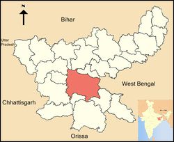
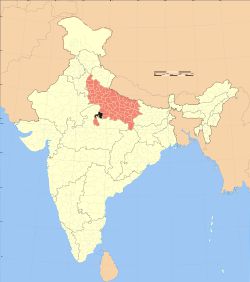
Ranchi (Jharkhand)
Ranchi district (Hindi: राँची जिला) is one of the twenty-four districts of Jharkhand state in eastern India. Ranchi city, the capital of Jharkhand state is the district headquarters. Read more...
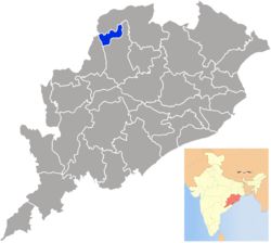
Jharsuguda (Orissa)
Jharsuguda is a district in Odisha, India with Jharsuguda town as its headquarters. The district once had an airport during World War II. Read more...
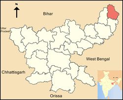
Sahibganj (Jharkhand)
Sahibganj district is one of the twenty-four districts of Jharkhand state, India. Sahibganj is the administrative headquarters of this district. Read more...
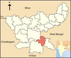
Seraikela (Jharkhand)
Seraikela-Kharsawan district (Hindi: सराइकेला खरसावाँ जिला,Odia: ଷଢେଇଖଳା ଖରସୁଆଁ ଜିଲ୍ଲା); formerly the Princely State of Seraikella/Saraikella is one of the twenty-four districts of Jharkhand state in eastern India. Seraikela town is the district headquarters of Saraikela Kharsawan district . Read more...
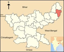
Pakur (Jharkhand)
Pakur district (Hindi: पाकुड़ जिला) is one of the twenty-four districts of Jharkhand state, India, and Pakur is the administrative headquarters of this district. The district, with a population of 899,200 (census 2011), and covering an area of 686.21 km², is situated on the north-eastern corner of Jharkhand state. Read more...
Palamu (Jharkhand)
Palamau is one of the twenty-four districts of Jharkhand state, India. Read more...
Khunti (Jharkhand)
Khunti district (Hindi: खूंटी जिला) is one of the twenty-four districts in South Chotanagpur division of the Indian state of Jharkhand. The district of Khunti was carved out of Ranchi district on 12 September 2007. It is historically known as the centre of activity of the Birsa movement. Read more...
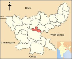
Ramgarh (Jharkhand)
Ramgarh district (Hindi: रामगढ़ जिला) is one of the 24 districts in the Indian state of Jharkhand. It was also a military district during the British Regime, referred to then as Ramghur district. Read more...
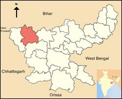
Latehar (Jharkhand)
Latehar district (Hindi: लातेहार जिला) is one of the twenty-four districts of Jharkhand state in eastern India, and Latehar town is the administrative headquarters of this district. This district is part of Palamu division. Read more...
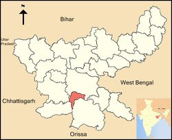
Simdega (Jharkhand)
Simdega district (Hindi: सिमडेगा जिला) is one of the twty-four districts of Jharkhand state, India, and Simdega town is the administrative headquarters of this districtis district was carved out from erstwhile Gumla district on 30 April 21. It is currently a part of the Red Corridor. As of 2011 it is the third least populous district of Jharkhand (out of 24), after Lohardaga d Khunti. Read more...
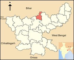
Koderma (Jharkhand)
Koderma district (Hindi: कोडरमा जिला) is one of the twenty-four districts of Jharkhand state, India, and Koderma is the administrative headquarters of this district. Koderma district was created on 10 April 1994, after being carved out of the original Hazaribagh district. Read more...
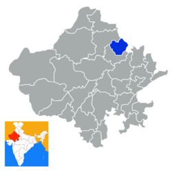
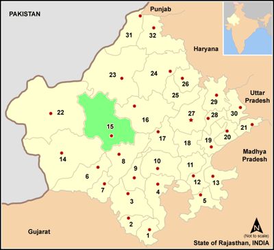
Jhunjhunu (Rajasthan)
Jhunjhunu district (Hindi: झुन्झुनू जिला) is a district of the Indian state Rajasthan in western India. The town Jhunjhunu is the district headquarters. Read more...
Jhansi (Uttar Pradesh)
संक्षिप्त परिचय-महारानी लक्ष्मी बाई की गौरव गाथा लिए झांसी शहर पूरे राज्य में प्रसिद्ध है. नगर में इतिहास से लेकर वर्तमान समय के विभिन्न पर्यटन स्थल हैं. यह जिला प्रदेश में अपनी शान के लिए जाना जाता है. हालांकि बड़े शहरों की तरह यहां लोगों की जिन्दगी में तेजी नहीं देखी जाती लेकिन यहां की सुस्त सड़कों में अपनापन महसूस कर सकते हैं.उत्तर भारत में स्थित झांसी जिला और आयुक्त मुख्यालय है. शहर की सीमा उत्तर दिशा की ओर जालौन जिले से, पूर्व में हमीरपुर और महोबा जिले से, दक्षिण की ओर से मध्य प्रदेश राज्य के टीकमगढ़ से, दक्षिण पश्चिम में ललितपुर जिले से जुड़ी हैं.ऐतिहासिक पृष्ठभूमि-झांसी पूर्व में मध्य प्रदेश के ललितपुर जिले के दतिया जिले से जुड़ा है जो पहाड़ी क्षेत्र में दक्षिण तक फैला हुआ है. इसे 1891 में झाँसी जिले में जोड़ा गया, और 1974 में फिर से एक अलग जिला घोषित कर दिया गया था.यह ऐतिहासिक शहर प्रदेश के दक्षिण में बुंदेलखंड की पाहुज नदी के किनारे स्थित है. झाँसी पहूज और बेतवा नद Read more...
Jhabua (Madhya Pradesh)
Jhabua district (Hindi: झाबुआ जिला) is a district of Madhya Pradesh state in central India. The town of Jhabua is the administrative headquarters of the district. Read more...
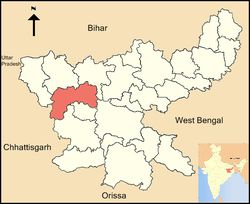
West Singhbhum (Jharkhand)
West Singhbhum or Pashchimi Singhbhum is one of the 24 districts of Jharkhand state, India. It came into being in 1990, when the old Singhbhum district was bifurcated. Read more...
Lohardaga (Jharkhand)
Lohardaga district (Hindi: लोहरदग्गा जिला) is one of the twenty-four districts of the Indian state of Jharkhand. The district is named after the town of Lohardaga, the administrative headquarters of the district. Read more...
Jodhpur (Rajasthan)
INTRODUCTIONJodhpur is the second largest city in the Indian state of Rajasthan and officially the second metropolitan city of the state. It was formerly the seat of a princely state of the same name. The capital of the kingdom was known as Marwar. Jodhpur is a popular Read more...
Jyotiba Phule Nagar (Uttar Pradesh)
Amroha District, previously known as Jyotiba Phule Nagar, is one of the 75 districts of Uttar Pradesh state in northern India.[2]Amroha town is the district headquarters. Read more...

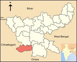
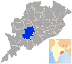
Kalahandi (Orissa)
Kalahandi (Odia: କଳାହାଣ୍ଡି, locally pronounced Kalahani), is a district of Odisha in India. The region had a glorious past and great civilisation in ancient time. Read more...
Sant Kabir Nagar (Uttar Pradesh)
संक्षिप्त परिचय- पूर्वी उत्तर प्रदेश में बसे संतकबीर नगर का नाम कबीर दास जी के नाम पर पड़ा. यह शहर राप्ती, घाघरा और कुआन नदी के तट पर बसा है. जिला क्षेत्रफल के लिहाज से वृहद तो नहीं है लेकिन अपनी सादगी और इतिहास के लिए जाना जाता है. ऐतिहासिक परिप्रेक्ष्य- संतकबीर नगर 5 सितंबर, 1997 को जिला बस्ती से बनाया गया था, जिसमें तहसील बस्ती के 131 गाँव और जिला सिद्धार्थ नगर की बांसी तहसील के 161 गाँव शामिल थे. यह जिला पूर्व दिशा में गोरखपुर, पश्चिम दिशा की ओर से बस्ती, उत्तर दिशा में सिद्धार्थ नगर और दक्षिण में अंबेडकर नगर के बीच स्थित है. जनसांख्यिकी- संतकबीर नगर जिले की कुल जनसंख्या 17,06,706 है. कुल आबादी में से पुरुषों की संख्या 8,65,195 तो वहीं महिलाओं की संख्या 8,41,511 है. क्षेत्र हिन्दी भाषी है. ग्रामीण क्षेत्र की आबादी 15,86,652 है. जिले में 1582 बसे हुए गाँवों और 144 निर्जन गाँवों के साथ 648 ग्राम पंचायतें और 1726 राजस्व गाँव हैं. प्रशासनिक ढांचा-< Read more...
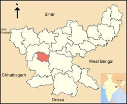
Kandhamal (Orissa)
Kandhamal is a district of the state of Odisha, India. The district headquarters of the district is Phulbani. Read more...
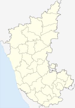
Raichur (Karnataka)
Raichur District is an administrative district in the Indian state of Karnataka. It is located in the northeast part of the state and is bounded by Yadgir district in the north, Bijapur and Bagalkot district in the northwest, Koppal district in the west, Bellary district in the south, Mahabubnagar district of Telangana and Kurnool district of Andhra Pradesh in the east. Read more...
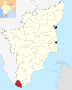
Kanyakumari (Tamil Nadu)
Kanyakumari (Tamil Nadu) - Census Data on Population, Households characteristics, Amenities, Forest Cover, Literacy, Schools, Healthcare, Density, Piped Water, Sewerage Connection, Drains Covered, Healthcare with comparative charts on Rural vs Urban profiles. Industrial and Employment Profile (Agriculture vs Industry Vs Services), including labor vs capital, Fuel, Industrial Input vs Industrial Output, Mobility, Action Groups and related stakeholders.Kanyakumari district also known as Kanniyakumari formerly known as Cape Comorin is a town in Kanyakumari District of Tamil Nadu state in India. The name doesn’t strike as a common name and definitely has a story behind it. Kanyakumari name comes from Goddess Kumari Amman or the Kanyakumari Temple, which is situated at the shore on the union of the Bay of Bengal, Indian Ocean and the Arabian Sea.Actually, Kanya Devi, an avatar of Parvati, was to marry Shiva, but she could not marry him, she vowed to rem Read more...
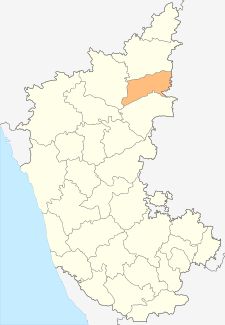
Yadgir (Karnataka)
Yadgir district (Kannada: ಯಾದಗಿರಿ ಜಿಲ್ಲೆ) is one of the 30 districts of Karnataka state in southern India. This district was carved out from the erstwhile Gulbarga district as the 30th district of Karnataka on 10 April 2010. Yadgir town is the administrative headquarters of the district. Read more...
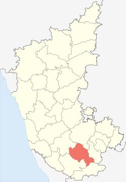
Mandya (Karnataka)
Mandya District is an administrative district of Karnataka, India. Mandya District borders on the south by Mysore District, on the west by Hassan District, on the north by Tumkur District and on the east by Ramanagar district. Read more...

Kaushambi (Uttar Pradesh)
कौशांबी: प्राचीन भारत की बौद्ध नगरी, जहाँ इतिहास साँस लेता है उत्तर प्रदेश के इलाहाबाद (प्रयागराज) मंडल में बसा एक ऐतिहासिक जिला — कौशांबी, जिसकी मिट्टी में बौद्ध धर्म की महक, मौर्य साम्राज्य की गूँज और गंगा-यमुना के संगम की पवित्रता आज भी जीवित है। यह वही भूमि है जो कभी भगवान बुद्ध के प्रवास स्थल के रूप में जानी जाती थी, और जहाँ सम्राट अशोक ने अपने शासनकाल में धर्म स्तंभ स्थापित कराया था। इतिहास की परतों में कौशांबी कौशांबी का नाम आते ही भारतीय इतिहास की सबसे प्राचीन नगरों की छवि उभर आती है। यह नगर महाजनपद काल (लगभग 600 ईसा पूर्व) में “कौशांबी महाजनपद” के रूप में प्रसिद्ध था। यह वत्स वंश की राजधानी रही और यहां के राजा उदयना की कथाएँ आज भी प्राचीन ग्रंथों में अमर हैं। बौद्ध ग्रंथों के अनुसार, भगवान बुद्ध ने अपने जीवन के कई वर्ष कौशांबी में व्यतीत किए। यही कारण है कि यहाँ के प्रत्येक टीले और स्तूप में अध्यात्म और इतिहास की गूंज महसूस होत Read more...
Karaikal (Puducherry)
Karaikal district (Tamil: காரைக்கால் மாவட்டம்) (also Karikal or Karaikkal) is one of the four districts of the Union Territory of Puducherry in India. Karaikal town (about 16 km north of Nagappattinam and 12 km south of Tarangambadi) is the regional headquarters. Read more...
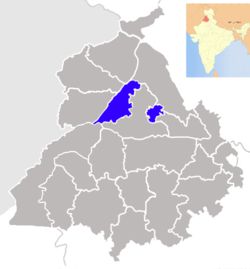
Kapurthala (Punjab)
Kapurthala district (Doabi: ਕਪੂਰਥਲਾ ਜ਼ਿਲਾ) is a district of Punjab state in northern Republic of India. The city of Kapurthala is the district headquarters. Read more...
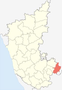
Kolar (Karnataka)
Kolar district (Kannada: ಕೋಲಾರ ಜಿಲ್ಲೆ pronunciation ) is a district in Karnataka state of India. The town of Kolar is the district headquarters. Read more...
Kanshiram Nagar (Uttar Pradesh)
Kasganj is 71st district of the Indian state Uttar Pradesh. It is located in the division of Aligarh and consists of Kasganj, Patiali andSahawar tehsils. Its headquarters is at Kasganj.[1] Read more...
 by Indian Engineers, Technocrats and Researchers.