
Chhindwara
INTRODUCTIONChhindwara is an urban agglomeration and a Municipal Corporation in Chhindwara district in the Indian state of <
BallotBoxIndia treats a district's development like a shared fund, and every socio-political innovator — leader, NGO, business, expert, journalist, activist — like a contributor whose impact we try to measure. The scores here are an experiment to tell apart what an innovator actually moved (नेता का हाथ · their real contribution) from what circumstance carried (हालात · the wave).
Reference data & background — source: Census 2011 & editorial notes, may be outdated
INTRODUCTION
Chhindwara is an urban agglomeration and a Municipal Corporation in Chhindwara district in the Indian state of Madhya Pradesh. It is the administrative headquarters of Chhindwara District.
Chhindwara is reachable by rail or road from adjacent citiesNagpur and Jabalpur. The nearest airport is in Nagpur (130 km); a
small airport (air-strip) is available at Chhindwara for landing charter
aeroplanes/helicopters. The population of the district is 2,090,306; most of
them are tribals with a growth rate of 13%, a sex ratio of .966 male/female.
The literacy rate is 81.46%. The
town itself has population of 234,784, with 89% literacy rate.
The name Chhindwara has been derived from the word 'chhind' which
basically is a name of a local tall tree surrounding the district. Chhindwara
District ranks first in area (11,815 km²) in Madhya Pradesh State and
occupies 3.85% of the area of the state. Chhindwara district was formed on 1
November 1956.It is on the southwest region of 'Satpura Range of Mountains'. It is spread from 21.28 to 22.49 deg.
North (latitude) and 78.40 to 79.24 deg. East (longitude) and spread over an
area of 11,815 km². This district is bound by the plains of Nagpur District
(in Maharashtra State) on the south, Hoshangabad and Narsinghpur districts on the north, Betul District on
the west and Seoni District on
the east.
CLICK HERE FOR OFFICIAL WEBSITE
HISTORY
It was believed that Chhindwara District was full of "Chhind"
(date palm or khajoor) trees many years ago, and the place was named
"Chhind"-"Wada" (wada means place). There is another story
that because of the population of lions it was considered that making entry
into this district is akin to entering the lions' den. Hence it was called
"Sinh Dwara" (means through the entrance of lion). In due course it
became "Chhindwara".
It is said that one Ratan Raghuwanshi,
who came from Ayodhya and killed the Gaoli chief of this region, founded
Chhindwara. Then he let loose a goat and on the place where it lay down built a
house, burying the goat alive under its foundations. A platform was erected
afterward on the spot. It is worshiped as the tutelary deity of the town. There
is a ruined mud fort at Chhindwara, within which there is an old stone house,
supposed to have been that of Ratan Raghuwanshi. A military force was stationed
at Chhindwara before the Great Revolt of 1857-58. For a short period the house
was used as a sanatorium for the Kamptee garrison.
The Gole Gunj market of the city, with
its two large gateways (known today as Kamania Gate), was built by Captain
Montgomery, who administrated the district as a regent of Richard Jenkins
(1818–1830). The municipality of
Chhindwara was founded in 1867.
In Chhindwara the
Gauli Rule existed before the advent of the Gonds. Deogarh on the Chhindwara plateau is believed
to be the last seat of Gauli power. According to legend, founder of the Gond
dynasty, Jatha slew and supplanted the Gauli chiefs Ransur and Ghamsur.
History records the place from the
time of the rule of King Bakht Bulund, whose kingdom was spread over the
Satpura range of hills and it is believed that his rule was up to the 3rd
century. One ancient plaque, belonging to Rashtrakut dynasty, was found in
Neelkanth village. This dynasty ruled up to the 7th century. Then came the Gondwana dynasty
which ruled the area with Deogarh as the capital. King Bakht Bulund was
most powerful in the dynasty and he has adopted Islam as his religion during the rule of
EmperorAurangzeb. Power changed many hands and Maratha rule ended in
1803.
On 17 September 1803, the British East India Company had taken over this kingdom by
defeating Raghoji II Bhonsle,
starting the British rule. Chhindwara district had been part of the Nerbudda (Narmada) Division of
the Central Provinces and Berar,
which became the state of Madhya Bharat (later Madhya Pradesh) after India's independence in 1947. After
Independence, Nagpur was made
the capital of Chhindwara District, and on 1 November 1956 this district was
re-constituted with Chhindwara as the capital.
INDUSTRIES
Following are few recognizable industries
that have contributed to the industrial development of Chhindwara:
Hindustan Unilever Limited
is a multinational company, originally from England. Earlier this company's
name was Hindustan Lever Limited. Chhindwara Hindustan Unilever Limited is in
village Lahgadua, 5 km from Chhindwara. This company completed 75 years in
2008. There are 210 workers in Hindustan Unilever, who work in three shifts.
The Chhindwara factory produces three main products: Rin washing soap, Wheel
washing powder, and Surf Excel washing powder. It is the only factory of
Hindustan Unilever in Madhya Pradesh. In 2007 the production was 70,000 units.
Raymond Group: The Raymond Chhindwara plant, set up in 1991,
is a state-of-the-art integrated manufacturing facility located 65 km from
Chhindwara. Built on 100 acres (0.40 km2) of land, the plant
produces premium pure wool, wool blend, and polyester viscose suiting. This
plant has achieved a record production capacity of 14.65 million meters, giving
it the distinction of being the single largest integrated worsted suiting unit
in the world.
Spices Park: India's first spice park was
opened in Chhindwara on 25 February 2009. The first in a series of seven parks
planned by the Spices Board is being set up with an investment of Rs 20 cr. The
initial phase of the park consists of a Garlic Dehydration Plant set up by the Spices Board and a Steam Sterilization Unit set up by
STCL Ltd., a public sector company. KITCO are the technical consultants for the project. The
park has come up in an area of 18 acres (73,000 m2) in Laas
village, Umranala, near Chhindwara in Madhya Pradesh on Chhindwara-Nagpur
Highway.
Amongst other large scale industries are Super Pack (Bajaj) at
Village Sawli near Sausar, Bhansali Engineering Polymers at village Satnur near
Sausar, P.B.M. Polytex Ltd. at village Borgaon near Sausar and Suryawanshi
Spinning Mills at village Rajna near Pandhurna.
Coal mines
Junnordeo, about 50 km from Chhindwara,
is the head office of the Kanhan area of WCL. It has Asia's largest coal wash
plant. It has around 15 coal mines in the Kanhan area. It has a big railway
coal transportation and its own importance in railways.
Parasia, about 30 km from Chhindwara, is known as the "Coal Mines Belt". There were 24 mines in this area, of which 20 mines are still working. The principal mines are Eklahara Mines, Burkuhi Mines, Chandametta Mines, Newton Mines, Donger Chikhali Mines, Mahadev Puri Mines. Ravanwara Mines, Ravanwara Khash, Vishnu Puri 11 No., Vishnu Puri 12 No., Chhinda Mines, Setiya Mines, Shivpuri Mines, Shivpuri Mines, Chhury Mines, Mathani Mines, Thisgora Mines, Nahariya Mines, Pench Mines, and Urdhan Project.
TOURIST ATTRACTION
The main tourist attractions in and around
Chhindwara include:
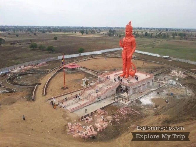
· Simariya Kalan- 101 feet Statue of Hanuman built by former union minister and current M.P of Chhindwara Shri Kamal Nath.
·
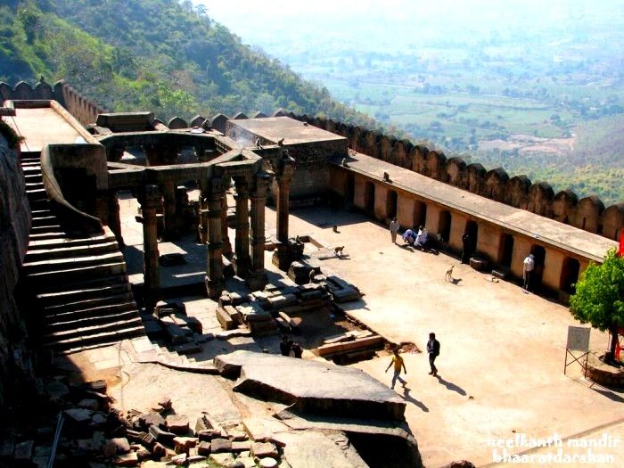
Devgarh Fort: This famous historical fort is 24 miles
(39 km) south of Chhindwara beyond Mohkhed. It is built on a hill which is
fortified by a deep valley clothed with dense reserve forest. The fort is
approachable up to its foot by motor road. The nature is bountiful here.
Devgarh Fort was built by King Jatav of Gond. It was the capital of Gondwana
dynasty until the 18th century. The architecture is somewhat similar to that of
Mughal. There are a big fort palace and beautiful buildings. It is believed
that there was a secret underground passage connecting Devgarh to Nagpur. Here
is a tank called "motitaka" and there is famous saying that the water
in this tank never finishes. At present, Devgarh village is a small
inhabitant's area. The ruins at this place speak of its past glory.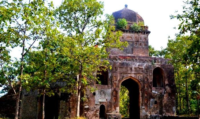
·
Patalkot,
in the hilly block 'Tamia' of Chhindwara District, has acquired great
importance because of its geographical and scenic beauty. Patalkot is a lovely
landscape located at a depth of 1200–1500 feet in a valley. Because of the
great depth, this place is christened as 'Patalkot' (patal menas very deep, in
Sanskrit). When one looks down from the top of the valley, the place looks like
a horseshoe in shape. Earlier, people believed it as the entrance to 'Patal'.
There is one more belief that after worshiping 'Lord Shiva' Prince Meghnath had gone to Patal-lok through this place only.
People say that this place was ruled by kings in 18th and 19th centuries and
that there was a long tunnel connecting this place to 'Pachmarhi' in
Hoshangabad District. Because of the inaccessibility of this area, the tribals
of this region were totally cut off from the civilized world. But, with the
constant efforts being made by the government, tribals of this area started
tasting the advantages of adopting civilized life. 'Patalkot' is attracting
many tourists because of its geographical location, scenic beauty, culture of
the people who live here, and the immense and rare herbal wealth.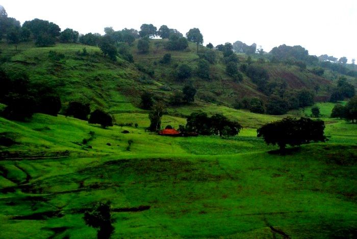
·
Tamia hills are around 45 km from Chhindwara.
The steep hills, dense forests, and big winding ghats have all combined to make
Tamia a beauty spot and a tourist place. A PWD rest house is picturesquely
situated on a steep hill commanding an extensive view of the deep forests and
mountainous ranges of Satpura notably Mahadeo and Chaura Pahad in the
background. The view from the rest house is noted for its constantly shifting
natural scenery which is inspiring to visitors. The government postal bungalow
in Tamia is a pleasant place as it is in hilly range at 3,765 feet
(1,148 m) height above Mean Sea Level surrounded by dense forest. The
sunrise and sunset scenes give a breath taking experience to the visitors.
About 1.5 km from this bungalow there is a cave where in the holy
'Shivling' (the deity of Lord Shiva) of 'Chota Mahadev' exists. Just beside the
cave is a small water fall. Both of these provide a feast to the eyes of the visitors.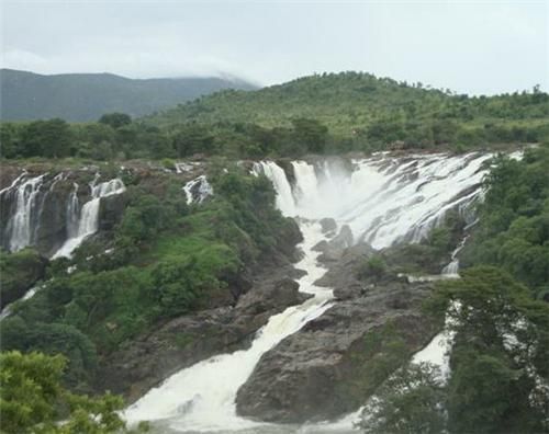
·
Gotmar Mela of Pandhurna: 97 km from
Chhindwara, in the headquarters of Pandhurna tahsil, a unique fair (mela in
Hindi) by name 'Gotmar Mela' is celebrated every year on the second day to
'Bhadrapad' New Moon day on the banks of the river Jam. A long tree is erected
in the middle of the river with a flag at its very top. The residents of the
villages Savargaon and Pandhurna gather on either bank and start pelting stones
('got') at the persons of the opposite village who try to cross into the mid of
the river and remove the flag on top of the tree trunk. The village whose
resident succeeds in removing the flag is considered victorious. The whole
activity happens amidst the chanting of the sacred name of 'Maa' Durgaji.
Several people have been wounded in this celebration and the district
administration made elaborate arrangements for the smooth conduct of this rare
fair. People have been left dead or injured, so the festival has now been
banned.Administration is now fail to stop the activity.
·
The Tribal Museum started in
Chhindwara on 20 April 1954 and acquired 'State Museum' status in 1975. On 8
September 1997 the Tribal Museum's name was changed to "Shri Badal Bhoi
State Tribal Museum". This museum is maintained by a Museum In-charge
Officer with the help of artists and peons. It comprises 14 rooms, 3 galleries
and two open galleries. It depicts the tribal cultures of 45 (approx.) tribal
communities living in Madhya Pradesh and Chhattisgarh states. It is the oldest
and the biggest tribal museum in Madhya Pradesh. It is a treasure house,
storing antique and rare collections of items related to the tribal living in
the district. One can find items related to the houses, clothes, ornaments,
arms, agriculture tools, art, music, dance, celebrations, the deities worshiped
by them, religious activities, herbal collections, and so on. The museum throws
light on the rich traditions and ancient cultures of the tribal communities. It
has depicted the family living styles of the ground and Baiga, the principal
tribes living in the district. Also it has shown how the Agria tribes mould
iron and shows Patalkots Dehia agricultural systems. These exhibits attract the
tourists. The museum is a one-stop collection-cum-information centre on the
tribes of this district.
·
Shashti Mata Mandir is located at Kapurda, almost
45 km north of Chhindwara. This temple is very old and famous for its
cultural influence on the region. It attracts a number of tourists almost every
day, but Tuesday is considered to be the best day for worship. It is believed
that if Shrashti Mata is invoked with faith, she dispels disease. Some visitors
come for the mundan ceremony (the
first hair cutting ceremony) of their children and offer their crop of hair at
the altar of goddess. Among other visitors, married couples come to invoke the
blessings of the goddess for a happy married life. This temple was built by
late B.L. Shrivastava in 1939. At present the temple management is taken care
of by his sons L.L. Shrivastava and S.S. Shrivastava and well supported by all
villagers but specially Mishra family has huge impact on that and managed all
events, functions with them. The temple can be reached by local buses or taxis
from Chhindwara.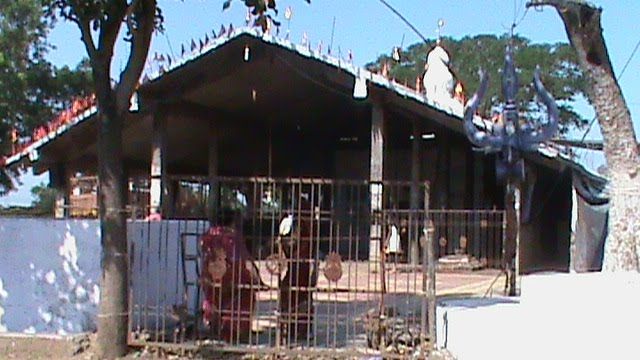
·
Waterfalls of Kukdi-khapa and Lilahi[DAHNORA] The picturesque
location of Kukdi khapa waterfall is found along the Chhindwara to Nagpur
narrow gauge railway line, between the stations of Umaranala and Ramakona. The
waterfall is situated in the panoramic 'Sillevani' mountain range. The height
of this fall is approximately 60 feet (18 m). The location is more
beautiful and picturesque immediately after a spell of good rains. While
travelling in the train along the narrow gauge railway toward Nagpur one can
see this beautiful picnic spot. The Lilahi[DHANORA]waterfall is located in the
downstream of the District's second biggest river, 'Kanhan'. This fall is situated on the route from Mohkhed to
Pandhurna via Devgarh. It is close to the 'Narayan Ghat,' near dhanora village
on the Kanhaan river. The lovely sight of the waterfall surrounded by mountain
rocks and colorful nature is indeed a feast to the visitor. The waterfall will
have a sufficient flow of water from July to January.
·
Anhoni village is near Mahuljhir Police
Station and at a distance of 2 miles (3.2 km) from the village Jhirpa on
Chhindwara-Piparia road. A hill stream with hot and boiling sulphur springs
flows near the village. These springs, at a further distance, assume the form
of a nullah (short stream). The water is believed to be beneficial for skin
diseases and for certain impurities of the blood.
· Neelkanthi: Some ruins of a temple can be seen by the side of Siphna stream which flows at some distance of Neelkanthi, a village which is 14 miles (23 km) south-east of Chhindwara town. The entrance gate to the main temple is said to date back between 7th and 10th century. It is believed that at one time an area of 264 x 132 sq ft (12.3 m2) inside the gate was surrounded by a rampart. The stone slabs of the gate are fastened together with iron hooks. An illegible inscription can be found on one of the stone pillars of the temple. There is a reference to Raja Krishna III of Rashtrakut kingdom. The design of the gate is in Bahmanic style.
·
Hinglag Mata Mandir, at Ambada (Mohan Colliery, Muari road)
almost 40 km (by the Parasia road) south of Chhindwara is one of the
notable temples in Chhindwara. It attracts a number of tourists almost every
day, but Tuesday and Saturday are considered to be the best days for worship.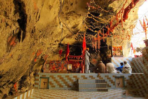
·
Ram Mandir, a Hindu temple dedicated to Lord Ram,
located at the heart of the city, is considered the oldest temple of the city.
It was constructed with the old beam and bracket system. In front of Ram mandir
there is Badi Mata Mandir, dedicated to goddess Durga.
·
Jama Masjid is located at Gole Ganj area, almost at
the centre of Chhindwara. It is considered as a historical place because it was
constructed by famous freedom fighters, the Shaukat Ali Brothers. The Masjid is
decorated by Arabic calligraphy, in Mughal and Turkish style.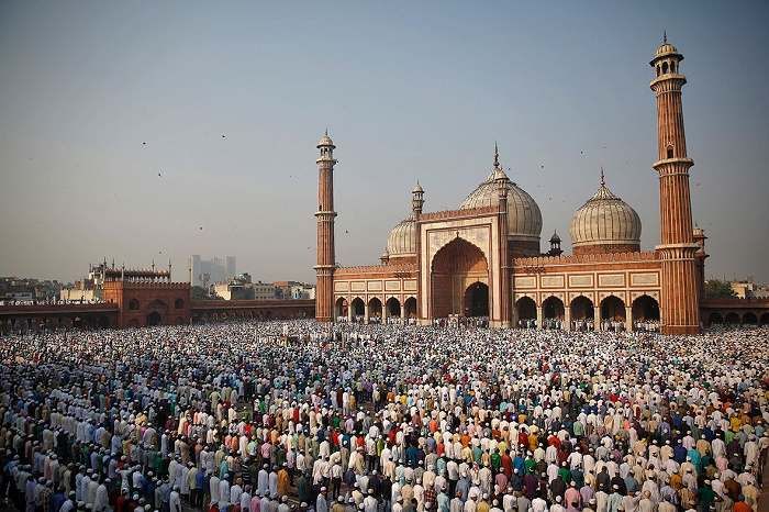
·
Sahaja Yoga Thousands of followers of Sahaja Yoga come every year
to Chhindwara to visit the birthplace of H.H.Shri Mataji Nirmala Devi,
founder of Sahaja Yoga. She was born on March 21, 1923 to a Christian family in
Chhindwara, India .
Her parents were Prasad Salve and Cornelia Salve,
direct descendants of the royal Shalivahana
dynasty. Seeing the beauty of this child who was born with a
spotless brilliance, they called her Nirmala, which means 'Immaculate'. Later
on, she came to be known by the multitudes by the name of H.H.Shri Mataji
Nirmala Devi — the revered Mother — who was born with her complete Self
Realization and knew from a very young age that she had a unique gift which had
to be made available to all mankind.[10] Her parents played a key role in India's
Liberation Movement from under British rule. Her father, a close associate of
Mahatma Gandhi, was a member of the Constituent Assembly of India and helped
write free India's first constitution. He was a renowned scholar, master of 14
languages, and translated the Koran into Marathi. Her mother was the first
woman in India to receive an Honors Degree in Mathematics.
CULTURE
Chhindwara District has a majority of tribal population.
The tribal communities include the Gond, Pardhan, Bharia, Korku. Hindi, Gondi,
Urdu, Korku, Musai, etc., so that many languages/dialects are in use in the
district. The majority of the tribal peoples speak in Gondi and Hindi mixed
with Marathi.
Among the most celebrated cultural
functions/festivals in the district are Pola, Bhujalia, Meghnath, Akhadi,
Harijyoti etc. The 'Gotmar Mela' of Pandhurna is a unique and world-renowned
fair. On Shivrathri day 'Mahadev Mela' is celebrated each year on
"chougadhh"
Chhindwara is the home of many famous
temples and mosques. The cheery and lovable nature of its people has made
Chhindwara a peaceful town with a rich culture. Many festivals and dances are
celebrated in Chhindwara and nearby villages. Sela dance, Gedi dance,
Nagpanchmi dance to name a few. Famous festivals in nearby villages include
Chouth ka dangal and panchmi ka mela.

Are you moving Chhindwara forward?
Local experts, journalists, representatives and activists — bring your action research and be credited for the milestones you move. No money changes hands here; the currency is your effort and analysis, donated to your community.
Get on the record →